|
Periods of Chinese History
|
 |
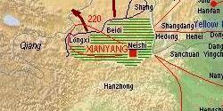
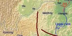
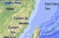
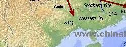
The dukes and kings of the Zhou period 周 (11th cent.-221 BCE) state of Qin 秦 (in the map signified by the green lined pattern) were among the first rulers to establish commanderies (jun 郡) in their territory as an administrative unit, instead of investing princes and persons that had won merits. When King Ying Zheng 嬴政 unified China and became the First Emperor of Qin 秦始皇帝 (r. 246-210 BCE), he dissolved the old regional states and established commanderies (names in black) in the whole territory of China. Some of them, especially the lands in the south where the native tribes of the Yue 越 lived (Nanyue 南越, Dongyue 東越, and Minyue 閩越), were incorporated for the first time into the realm of China. The capital was Xianyang 咸陽 (modern Xianyang, Shaanxi). The territory near the capital (neishi 內史) was directly administered, a measure still in practice during the following dynasties.
The commanderies of the Qin empire were:
Center, W and S:
Neishi 內史
Longxi 隴西郡
Shang 上郡
Jiuyuan 九原郡
Yunzhong 雲中郡
Beidi 北地郡
Ba 巴郡
Shu 蜀郡
Qianzhong 黔中郡
Nan 南郡
Hengshan (1) 衡山郡
Changsha 長沙郡
Jiujiang 九江郡
Huiji 會稽郡
Minzhong 閩中郡
Nanhai 南海郡
Guilin 桂林郡
Xiang 象郡 |
East:
Sanchuan 三川郡
Nanyang 南陽郡
Yingchuan 潁川郡
Chen 陳郡
Dong 東郡
Dang 碭郡
Sishui 泗水郡
Jibei 濟北郡
Xue 薛郡
Linzi 臨淄郡
Jiaodong 膠東郡
Langya 琅邪郡
Donghai 東海郡 |
Northeast:
Hedong 河東郡
Henei 河內郡
Shangdang 上黨郡
Handan 邯鄲郡
Julu 巨鹿郡
Taiyuan 太原郡
Hengshan (2) 恆山郡
Yanmen 雁門郡
Dai 代郡
Shanggu 上谷郡
Guangyang 廣陽郡 (modern Beijing)
Yuyang 漁陽郡
Youbeiping 右北平郡
Liaoxi 遼西郡
Liaodong 遼東郡 |
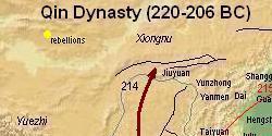
To defend his empire against the intruding northern nomad tribes like the Xiongnu 匈奴 and Hu 胡 (rather a general term for "barbarians"), a long fortification wall, today known as the "Great Wall 長城, was built along the northern frontier, in the map shown as a black line.
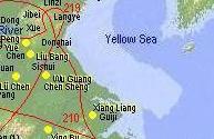
A very important instrument to control the local governors were the inspection tours of the First Emperor, in the map shown with red lines. In 210, the emperor died during an inspection tour (big dot). After his death local leaders rose against the Qin dynasty, defeated the imperial armies and sacked the capital.
Source: Tan Qixiang 譚其驤 (ed. 1987), Zhongguo lishi ditu ji 中國歷史地圖集, Vol. 2, Qin, Xihan, Donghan shiqi 秦·西漢·東漢時期 (Beijing: Zhongguo ditu chubanshe).
October 30, 2011 © Ulrich Theobald · Mail
|
|

Map and Geography

Event History

Emperors and Rulers
Government and Administration

Literature and Philosophy

Religion

Technology and Inventions

Economy

Arts
|