ChinaKnowledge.de -
An Encyclopaedia on Chinese History, Literature and Art
| Yumen Pass 玉門關 |
| Loulan 樓蘭 |
| Moshan 墨山 (Shanguo 山國) |
| Huhu 狐胡 |
| Weixu 危須 |
| Quli 渠犁 (Korla, Ch. Ku'erle 庫爾勒) |
| Weili 尉犁 (Karakum) |
| Yanqi 焉耆 (Karašahr) |
| Wulei 烏壘 (Yengisar) |
| Qiuci 龜茲 (Kuča, Ch. Kuche 庫車) |
| Gumo 姑墨 (Aksu) |
| Wensu 溫宿 (Uš, Ch. Wushi 烏什) |
| Weitou 尉頭 |
| Shule 疏勒 (Kašgar) |
| Shanshan 鄯善 |
| Ruoqiang 若羌 |
| Qiemo 且末 (Čerčen) |
| Xiaowan 小宛 |
| Jingjue 精絕 |
| Ronglu 戎盧 |
| Yumi 扜彌 |
| Qule 渠勒 |
| Yutian 于闐 (Hetian 和田, Khotan) |
| Pishan 皮山 (Guma) |
| Shache 莎車 (Yarkant) |
| Yiwu 伊吾 (Hami 哈密, Tang-period Yizhou 伊州) |
| Gaochang 高昌 (Turfan, Ch, Tulufan 吐魯番, Tang-period Xizhou 西州) |
| Cheshi 車師 (or Gushi 姑師) |
| Jie 劫 |
| Qiemi 且彌 |
| Beilu 卑陸 |
| Yizhi 移支 |
| Pulei 蒲類 |
| Danhuan 單桓 |
| Yulishi 郁立師 |
| Wutanzili 烏貪訾離 |
| Suiye 碎葉 |
| Beiting 北庭 (Jimusa'er 吉木薩爾) |
| Luntai 輪臺 |
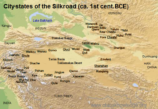 |
Click on the names to learn more about individual city states. Map, reflecting the situation during the Han period, according to Tan 1982, Vol. 2, 37-38, 65-55. |