October 30, 2011 © Ulrich Theobald
Chang'an 長安 (modern Xi'an 西安,Shaanxi) the Former Han empire 前漢 (206 BCE-8 CE) was administrated in regions or "provinces" (zhou 州; in the map in courier type and underlined) and subordinated commanderies (jun
郡) and princedoms (wangguo
王國; in violet letters). The number of princedoms changed during the
four centuries of Former and Later Han periods, but it can be observed that the
main areas of princely states were the modern provinces Shandong,
Jiangsu and Hebei. When Liu Bang 劉邦 became emperor of Han (Han Gaozu
漢高祖, r. 206-195 BCE) he made seven of his followers kings (regional rulers), the so-called non-familiar
princes (yixingwang 異姓王; underlined red).
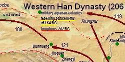
In 154 BC seven princes rebelled against Emperor Jing 漢景帝
(r. 157-141 BCE, underlined yellow). The capital region was called Sili 司隸 "Directly
administered", and the capital commandery was the Jingzhao gouvernement 京兆尹.
Regions or provinces (zhou 州) of the Han Empire |
| region | modern location |
| Sili 司隸 | southern Shaanxi |
| Shuofang 朔方 | northern Shaanxi |
| Liangzhou 涼州 | Gansu |
| Bingzhou 幷州 | Shanxi |
| Jizhou 冀州 | southern Hebei |
| Youzhou 幽州 | northern Hebei, Beijing, Tianjin, Liaoning |
| Qingzhou 青州 | Shandong |
| Yanzhou 兖州 | northern Anhui, Henan |
| Xuzhou 徐州 | northern Jiangsu |
| Yangzhou 揚州 | southern Jiangsu, Shanghai, southern Anhui, Zhejiang, Fujian |
| Jingzhou 荊州 | Hubei, Hunan, Guangxi, Guangdong, Guizhou |
| Yizhou 益州 | Sichuan, Chongqing, Yunnan |
| Jiaozhi 交趾 | Hainan, north of modern Vietnam |
Under
Emperor Wu 漢武帝 the great expansion of the Han empire took
place, first by defeating the
Xiongnu
匈奴, then by the advance of Chineses armies, and later colonists, into
modern Gansu province,
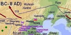
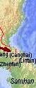
Korea
(from the commanderies Lelang/Nangnang 樂浪, Canghai/Changhae 蒼海, Lintun/Imdun 臨屯
and Zhenfan/Chinbŏn 真番 only the first was permanent; Xuantu/Hyŏndo 玄菟
was later moved westwards), Yunnan province and Guangzhou province and
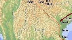
the north of modern Vietnam (commanderies Jiaozhi/Giao Chỉ 交趾,
Jiuzhen/Cửu Chân 九真 and Rinan/Nhật Nam 日南). The
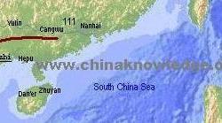
commanderies on the
island of Hainan were only temporary. The
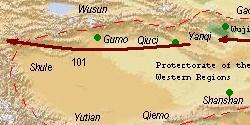
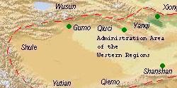
Protectorate of the Western
Regions (
xiyu duhufu 西域都護府) over the city states of the
Silk Road
with the seat in
Wulei 烏壘 (modern Luntai 輪臺, Xinjiang) was established
in 60 BC. A special zone was the
Commandery of Wuji 戊己校尉 (modern
Turfan 吐魯番, Xinjiang)
from where the region of the kingdoms of
Cheshi 車師 and
Gaochang 高昌 were
governed. In all northwestern regions the Han rulers had established
military agro-colonies (
tuntian 屯田; green dots).
The northern neighbours of the Former Han empire were the mighty nomad
confederations of the Xiongnu, the
Wusun 烏孫,
Wuhuan 烏桓 and
Xianbei 鮮卑.
Chinese military campaigns and emissaries were even sent further west
into the land of the
Yuezhi 月氏 that are sometimes identified with the
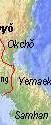
Skythians. While the Manchurian Basin and the mountain areas of modern
North Korea were inhabited by the peoples of
Fuyu/Puyŏ 夫余 and
Huimo/Yemaek 濊貊, the south of the Korean Peninsula was roamed by the
Three Han tribes (Samhan/Sanhan 三韓): Mahan 馬韓, Chinhan/Chenhan 辰韓,
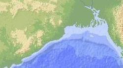
Pyŏnhan/Bianhan 弁韓. The southwest that was incorporated into the Han
empire in 109 BC the former kingdoms of
Dian 滇 and
Ailao 哀牢 became
tributaries. Rebellions often occured like in 86 BC. The modern
province of Fujian was still scarcely populated and did not really
belong the the Han empire partially because this territory was too
mountainous and less interesting for colonization, and because it was
still dominated by the belligerent tribes of the
Min-Yue 閩越 and Eastern
Ou 東甌.
Apart from some
minor changes the governmental structure of the Former Han was
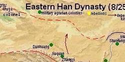
perpetuated by the Later Han 後漢 (25-220 CE) government. The three most important innovations or changes are the
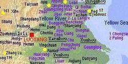
shifting of the capital to Luoyang 雒陽 (or 洛陽 modern Luoyang, Henan), the new
Administration Area of the Western Regions (
Xiyu changshifu
西域長史府) with the seat in
Qiuci 龜茲, and the installation of dependent
non-Chinese kingdoms (
shuguo 屬國) in border regions (slim brown arrows).
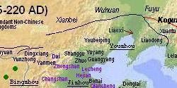
From the time of the usurper
Wang Mang 王莽 (r. 8-25 CE) on China was shaken by rebellions and
uprising, beginning with the movement of the "
Red Eyebrows" (
Chimei
赤眉) and the Lülin 綠林 armies that made an end to the reign of
Wang Mang,
uprisings of tribes and peoples in the southwest (in the region of
Yizhou 益州, modern Yunnan several times, the resistance war of the two
Vietnamese sisters "Hai Bà Trưng" Trưng Trắc 徵側 and
Trưng Nhị 徵貳), and the numerous rebellions of the
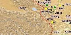
proto-Tibetan
Qiang 羌 people in Liangzhou 涼州 (modern Gansu and Shaanxi
provinces). But the most striking uprisings that contributed to the end
of the central government of the Later Han Dynasty were the religious
movements of the "
Yellow Turbans" 黃巾 that
originated in modern Sichuan and Hebei, and the
Five-Pecks-of-Grain
movement 五斗米道 of
Zhang Lu 張魯.
The mighty steppe federation of the Xiongnu was crushed during the end of
former Han, and other peoples replaced these warriors of the steppe.
But both the Wuhuan and the Xianbei had intensive diplomatic and trade
relations with the Han empire and were partially forced to settle down.
In Korea the kingdom of Koguryŏ/Gaogouli 高句麗 started to dominate the
north of the peninsula. The southeastern area was now brought under
control of the Han empire, and the commandery of Yongchang 永昌 should
govern the non-Chinese mountain tribes.
Sources:
Tan Qixiang 譚其驤. ed. (1987). Zhongguo lishi ditu ji 中國歷史地圖集, Vol. 2, Qin, Xihan, Donghan shiqi 秦·西漢·東漢時期 (Beijing: Zhongguo ditu chubanshe).