ChinaKnowledge.de -
An Encyclopaedia on Chinese History and Literature
Xizang tushuo 西藏圖說, also called Xizhao tushu 西招圖書 or Xizhao tushuo 西招圖說, is a collection of commented maps of Tibet compiled by Sungyūn 松筠 (1752-1835), courtesy name Xiangpu 湘浦, from the clan Malite 瑪拉特氏 of the Mongolian Plain Blue Banner (Menggu zhenglan qi 蒙古正藍旗). He began his career as a scribe (bithesi 筆帖式) in the Court of Colonial Affairs (lifanyuan 理藩院) and later became Secretary in the Council of State (junji zhangjing 軍機章京). For his abilities he was promoted to Academician in the Grand Secretariat 內閣學士 and was concurrently promoted to Vice Commander-in-chief of a Banner (fu dutong 副都統).
In 1785 he was made resident minister (Man. amban, Chin. banshi dachen 辦事大臣) of Kulun 庫倫 (old name of Ulaan Baatar), and in 1794 resident minister of Tibet (Ch. zhu Zang banshi dachen 駐藏辦事大臣). In 1802 he was transferred to the post of General of Ili (Yili jiangjun 伊犁將軍).
The map collection, consisting of 15 charts, begins with an overview map, and then proceeds to maps of individual regions, all seen from the north, and drawn in a traditional "three-dimensional" Chinese mode, showing mountains, rivers, roads, cities, castles monasteries and garrisons. The map reaches from Dartsedo 打箭爐 (Kangding 康定) in the east to the border to Nepal in the west. The descriptive texts provides further information on passes, climate and other local conditions. An appendix gives information on the courier routes from Chengdu to Tsang, Ü, and on to Xining 西寧 in the far west.
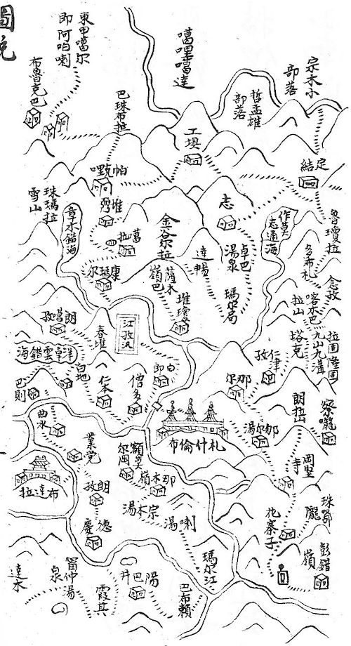 |
Overview map of Tibet, with the Potala (Ch. Budala 布達拉, bottom left) and Tashi Lhunpo Monastery (Ch. Zhashilunbu 札什倫布, just below the centre of the map, in square mark), the military post of Gyangtse (Ch. Jiangzi xun 江孜汛), lakes, roads (in tiny strokes, looking like corduroy roads), rivers (unfortunately without names), mountains, cities, passes, bridges. South top, north bottom. |
Sungyūn's maps were based on military maps and served later books on Tibet as a blueprint, for instance, Suifu jilüe 綏服紀略, Xizhao jixing shi 西招紀行詩, Qiuyue yin 秋閱吟 or Xizhao tulüe 西招圖略.
The book was printed in 1823 and 1847. The series Zhongguo bianjiang congshu 中國邊疆叢書 includes the facsimile of a manuscript version.